Geography of the Ancient Middle East
(See Map handed out Week 1)
(See Handout passed out in Class 10-9-14---I will post a link or a copy when Kyra emails the class review)
There are three regions in what is known as the Fertile Crescent (Listed West to East and must be in order):
~Mesopotamia
~Syria/Palestine
~Egypt
Mesopotamia
Mesopotamia is the home of the Patriarchs in the area around the city of Ur and Susa. Abraham came from this area. When Daniel was brought to this area as a captive Isaealite he was, in a sense, "going home." The significance here is that Daniel remained loyal to his God (the God of Abraham) withstanding the pressures from those living in this area who owed personal allegiance to thier own Gods who spent a good deal of time and effort "cheer leading" for their Gods trying to convert Daniel.
Mesopotamia means "Land Between Two Rivers." Those rivers are the Tigris and Euphrates. Present day Iran and Iraq have within their borders portions of Mesopotamia. The city of Ur, the capitol, is in present day Iran. Mesopotamia is the place that saw the invention of Sumerian Cuneiform Writing of the first forms of of writing in the Early Bronze Age. It took until the middle 1900s to decipher this writing.

Syria/Palestine
Syria/Palestine is the only land bridge that connects 3 continents: Africa, Asia, & Europe. Most of the Old and New Testaments take place here.
Egypt
Egypt is one of the earliest Advanced Civilizations. The major reason is the Nile River. The river provided fertility supporting agriculture and allowed shipping of those products that allowed commerce unlike any other area in the region.
Egypt is where Hieroglyphics was invented. They were not deciphered until the mid 19th Century.
All of these things are important to understand Biblical and extra-biblical writings, archaeological finds, etc. All these things tie in to give us a fuller picture of what we will be studying.
Geographical Sub-Divisions of Syria/Palestine
Syria/Palestine is divided into sub-regions:
Longitudinal Zones and Latitudinal Zones
Longitudinal zones can be understood as regions that run roughly north to south, following lines of longitude.
From West to East they are:
~Coastal Plains: The area on the shoreline of the Mediterranean ocean. AKA the land of Canaan. this is where the Philistines lived.
~The Hill Country (AKA Central Mountain Range): The area just west of the Jordan River. Most of the Israelite towns and cities are here.
~The Jordan Rift: The area immediately east of the Dead Sea.
~The Trans-Jordan
Latitudinal Zones can be understood as regions that run east to west, following lines of latitude. From North to South they are:
~Galilee
~Samaria AKA Ephriam
~Judea AKA Judean Hills
~Negeb (Negev)
These areas can overlap. Examples can be seen here:
 | |||||||
Map of Israel's Natural Divisions (Bible History Online)
The land of Israel can be divided into four main geographical regions: The Coastal Plain, the Hill Country, The Great Rift of the Jordan Valley, The Transjordan Hig...
| |||||||
Preview by Yahoo
| |||||||
Where Upper and Lower Galilee overlap the Coastal Plains and the Central Mountain range.
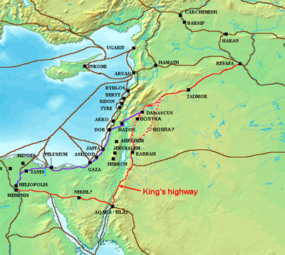
Important Highways
Rhere were two main higways in the region that connected Egypt with the ports at Sidon and Tyre (on the Coast Plain of Syria/Palestine)
1. The Kings Highway
2. The Via Maris AKA The Way Of The Sea.
 | |||||||
Ancient World History: King’s Highway and Way of The Sea
There were two main highways in ancient times between Mesopotamia, Egypt, and the lower Arabian Peninsula: the King’s Highway and the Way of the Sea.
| |||||||
Preview by Yahoo
| |||||||
Amplifications to the Biblical Archaeology Handout
To correctly interpret Ancient Writigns, we must understand the culture. We cannot project 21st Century culture and values onto theirs. What made sense to them would not make sense to us.
One way to remember that a Tel is ruins that are completely buried is to walk out and look around and say "There's no telling what's buried here."
The Behistun Rock is 1700 feet high and about the size of 1/2 a football field. The inscription on it runs from about 300 feet to 1700 feet. Melted lead was used to make the surface of the rocks flat enough to make inscriptions on it. By the time the rock was discovered two of the three languages used in the inscriptions had been deciphered (Elamite and Old Persian) which helped us decipher the Mesopotamian Cuneiform used in writing the Babylonia inscriptions.
 | |||||||
Behistun Historic Site
Contents Behistun Site Description, Contents, Location Site Name Stories Surrounding Behistun Inscriptions of Darius I, the Great Size & Situation Content Languages...
| |||||||
Preview by Yahoo
| |||||||
The Rosetta Stone was found in 1799 and was fully deciphered by 1822. It two had three languages on it and two of those languages, Demotic and Greek, were already known which helped the deciphering of the Egyptian Hieroglyphics. Hieroglyphics were used by the Egyptians to record important texts and pronouncements of religion and government. Demotic was the language used by the common folk. By the time the stone had been inscribed in196 BC by commission from Ptolemy V, Greek had been declared the "lingua franca" of the ancient world by Alexander the Great (see week 1)

First test will be next week at the beginning of clas. Multiple choice, matching and true/false.
Everything on this week's handout starting with the definition of "Tell" will be on the test.
Below are notes taken by Roxie Casall:
biblecollegenotes@blogspot.com
sargevining@yahoo.com
Geography of Israel and Ancient Near East
The Fertile Crescent is made up of 3 regions:
1. Mesopotamia
- Means land between 2 rivers: Tigris and Euphrates Rivers
- Present day Iran and Iraq
-Mesopotamia is the ancestral home of the patriarchs in a town called Ur sometimes it’s called Ur of the Chaldees. (Ur is where present day Iran is located).
-Town of Susa: In the in time of Daniel, people were polytheistic (belief in many gods) but Daniel believed in ONE GOD, our God! This was a homecoming for Daniel since he was back in the land where his family was from. His father and grandfather were from there and they were polytheistic.
-Invention of Sumerian Cuneiform Writing: one of the first forms of writing in Early Bronze Age. Deciphered in middle 1900’s.
2. Syria – Palestine
-Only land bridge that connects 3 continents: Africa, Asia and Europe.
-It’s the setting of where the majority of the New Testament takes place.
-(See Longitudinal and Latitudinal Zones on next page)
3. Egypt
-They enjoyed one of the earliest advanced civilizations because of the Nile River providing them with commerce: shipping industry, imports/exports, etc.
-Invention of Hieroglyphics. Deciphered around 1854, mid 19th century.
*These regions give us extra biblical writings, findings and communication. All these things give us a picture of what we will be studying in the Old Testament.
We are in the Region of Syria – Palestine but focusing in more…
Longitudinal Zones: Make North and South lines and create zones
Zone 1:
Coastal Planes
Philistines live here Zone 2:
Hill Country
aka Central Mountain Range
Most Israelite cities and towns are here Zone 3:
Jordan Rift Zone 4:
Transjordan
Latitudinal Zones: Make East and West lines and create zones
Zone 1: Galilee
Zone 2: Samaria also known as Emphraim
Zone 3: Judea also known as Judean Hills
Zone 4: Negeb
There were 2 Important Highways:
-Went from region of Egypt all the way up to Tyre and Sidon
-One was called the Kings Highway and it ran more inland
-The other was called the Via Maris also known as the Way of the Sea
Biblical Archaeology Handout Extras:
Behistun Rock: King Darius took melted lead and made the side the mountain flat so that they could inscribe on it.
Rosetta Stone: found in 1799 and deciphered in 1822. Egyptian hieroglyphics was used for things of great importance, religion, government, etc. Egyptian Demotic was common language.
Nuzi Tablets: The book of Genesis has traditions and cultures from this region. Jebusites and Hivites.
No comments:
Post a Comment